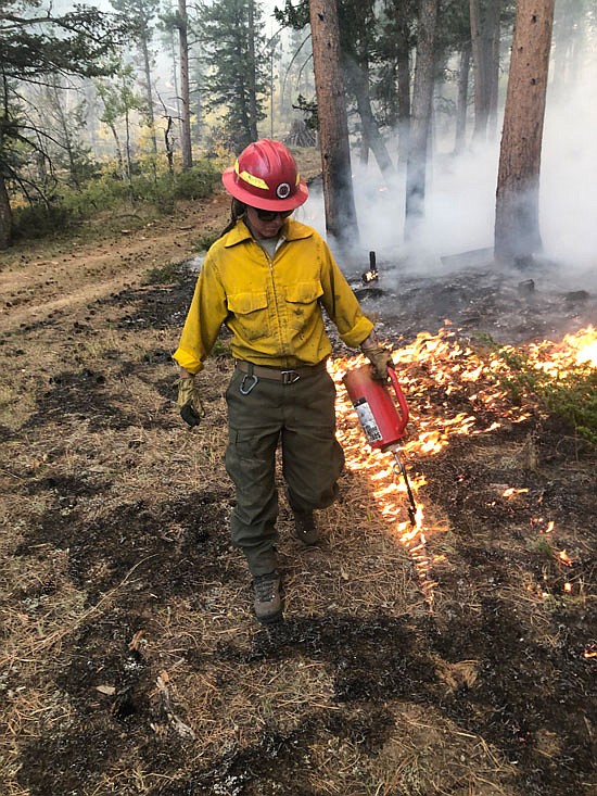
Sammie Davis assists the Bitterroot Hotshots with a backburn on the Cameron Peak Fire in Colorado in August.
Courtesy
As wildfire risks in Western Washington increase, Snohomish County officials are developing a county-wide protection plan.
The county is surveying residents to provide information about the area’s preparedness that will be used to develop the plan. The survey went live in early August and will be available until mid-November. The survey can be accessed at www.bit.ly/snoco_wildfire_survey
County officials are particularly interested in the safety of people who live near large areas of trees and vegetation, known as the wildland-urban interface.
Amy Lucas, project manager with the county’s Community Wildfire Protection Plan, said the survey will provide information about the values of people who live in the wildland-urban interface area with the people who recreate and others who pass through the area. “What are all of the different interests and priorities that we should balance as we develop this plan?,” Lucas said.
Details about the county’s Community Wildfire Protection Plan can be found at www.snohomishcountywa.gov/4113/Community-Wildfire-Protection-Plan
She added that construction in the Pacific Northwest is based on the historic climate.
“We really don’t have structures that are mitigated against wildfires,” Lucas continued. “It’s just that shift of understanding that climate is changing that we need to provide defensible space around our homes, and neighborhoods and our communities and getting that knowledge out to the public.”
She said people cause most wildfires, ranging from campfires that haven’t been fully extinguished to activities such as target shooting, or parking a hot car over long grass.
Human-caused wildfires are anything that isn’t naturally occurring, such as a lightning strike, said Lucia Schmit, Snohomish County’s Director of Emergency Management.
Lucas added that a lot of areas that were logged in the ‘70s and ‘80s were replanted by seeding by helicopter, and Schmit said this created forests that became denser than what someone would see in a natural environment.
Lucas said aerial seeding led to patches of monoculture where one species of tree takes over an area, which is bad for wildfire risk and forest health.
Developing a plan comes after the Bolt Creek Fire that took place for six weeks in 2022 and burned more than 14,700 acres in Snohomish and King counties.
“The Bolt Creek Fire is just kind of a sign of the things to come,” Schmit said. Summers are getting drier and hotter, she said.
Wildfire protection planning is common east of the Cascades.
Work on Snohomish County’s wildfire protection plan started in January and will take two years to complete. Officials have found that around 130,000 people in Snohomish County, more than 15 percent of the population, live in areas where homes, businesses and farms stand in the trees (the wildland-urban interface), according to a press release from the Snohomish County Department of Emergency Management.
Eric Andrews, chief of Sky Valley Fire, said the fire district developed a wildfire protection plan in 2018. His fire district heavily responded to the Bolt Creek Fire.
Sky Valley Fire District has about 60 personnel who cover around 200 square miles that goes to the King County line and the Chelan County line, Andrews said. The district includes the cities of Index and Gold Bar.
Andrews said the protection plan delves into the aftermath of a fire. The plan will also include how to deal with destroyed homes, temporary housing, and how organizations such as the Red Cross would get involved.
Fire districts, as well as cities, community organizations, the Snohomish Conservation District, the forest service and the state Department of Natural Resources are participating in the planning effort, Schmit said.
The Community Wildfire Protection Plan will help fire districts access grant funds, Lucas said.
Snohomish County is receiving a $250,000 County Wildfire Defense Grant from the U.S. Department of Agriculture to help with planning. The grant will fund the development of a public engagement plan and other actions.
More than 600 people so far have responded to the survey, said Scott North, public information officer with the Snohomish County Department of Emergency Management. Lucas said she hopes to see at least 1,000 responses by the time the survey window closes in November.
North said “tens of thousands” of people who have signed up for the county newsletter know about the survey and it is promoted on every county social media channel.
“The wildfire issue in our community is pretty complicated so the more people learn, the better we will all be,” North said.
-------
Snohomish Conservation District offers wildfire protection help
One resource county officials recommended homeowners can tap to learn how to protect their homes from potential wildfires is the Snohomish Conservation District, which has resources to help owners who have property in the wildland urban interface, said Amy Lucas, program manager with Snohomish County’s Community Wildfire Protection Plan.
The Conservation District’s wildfire resilience page can be accessed at www.
snohomishcd.org/wildfire-resilience.
Conservation District staff can also visit a home and conduct an assessment to determine potential risks and possible solutions to protect a home from a wildfire, according to the Snohomish Conservation District website.
Residents living in Arlington, Camano Island, Darrington, Gold Bar, Granite Falls, Lake Stevens, Marysville, Monroe, Snohomish, Stanwood, and Sultan can sign up for a site visit. Go to the Snohomish Conservation District’s wildfire resilience page and click “request site visit” near the bottom.