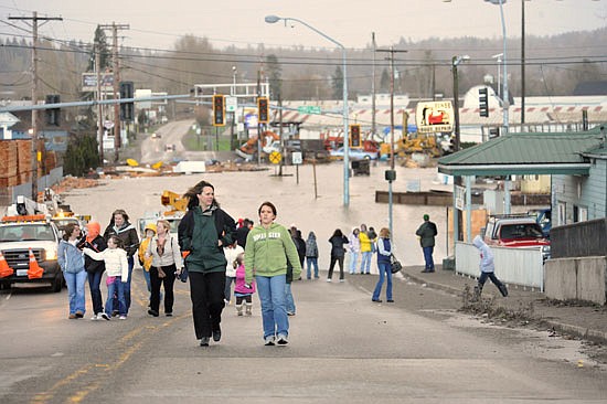
Floodwaters reached 33.49 feet in Snohomish on Jan. 8, 2009. Here, spectators criss-crossed the Avenue D bridge to go see the flooded-over intersection of Airport Way and Lowell-Snohomish River Road.
Doug Ramsay
SNOHOMISH COUNTY — This year’s high precipitation levels may set Snohomish County’s rivers up for a flooding situation in January.
As peak flood season arrives, the National Weather Service forecasted the Snohomish River to rise this week. Although the probability is low, there is a chance for the water level to reach as high as 18 feet at the Snohomish River water level gauge west of Monroe. Major flooding begins at 17 feet, and on Feb. 2 this year, the water level in Monroe reached over 18 feet.
Snohomish County Public Works sent out 8,000 pamphlets titled “Flood Safety in Snohomish County” in November to those living within the 100-year floodplain. The pamphlet includes information regarding flood preparation and recovery, property risks and protection, as well as emergency contact information. Public Works has provided numerous resources for before, during and after flooding. Visit https://snohomishcountywa.gov/796/Flood-Information-Center for flood resources and additional information.
Snohomish County residents are anticipating more flooding this year due to the 2020 La Niña weather pattern. A La Niña creates wetter-than-normal conditions and below-average temperatures. The last major floods occurred in early 2009, coincidentally a La Niña year. Water levels reached over 33 feet in Snohomish and over 24 feet in Monroe.
The Snohomish River water gauges in Snohomish and Monroe differ in phases of flood severity based on the river’s level. In Snohomish, the river enters a phase two flood risk with river levels of 25 feet, causing overflow onto Old Snohomish-Monroe Road. Phase three starts at 27 feet, and there is over-topping onto Riverview Road, Rivershore Road and Lowell-Snohomish River Road at 29 feet. Stage four is when the water level is 30 feet and higher, with the river near the top of all the levees. At 31 feet, major flooding starts along Riverview Road, Rivershore Road and the Ebey Slough levee.
Near Monroe, the phase of severity for the Snohomish River increases quickly beginning with phase two at 15 feet, phase three at 16 feet and phase four at 17 feet. Low pasture lands in the river valley will flood as well as several roads. At 20 feet, the river floods severely throughout the valley,
affecting many homes, closing roads, and flooding farmland. At 22 feet, floodwaters are deep and destructive, inundating farmland, damaging levees and roads.
The level of response by the county is measured in four phases.
In phase one, flooding is rare but county staff is alerted. Phase two includes 24-hour observation of river gauges and flood conditions. The county Emergency Operation Center opens and flood information phone lines are updated hourly with current river level information. In phase three, county investigation crews are sent to monitor levees and flood control facilities. In phase four all agencies respond to a major flooding event causing widespread damage.
Flooding is difficult to predict until the water level begins to rise. The perfect conditions for a major flooding situation often occur quickly and with little warning. The county’s Department of Emergency Management offers resources for preparedness including hazard maps and options to receive emergency alerts.
Visit https://snohomishcountywa.gov/180/Emergency-Management for more information.
Past major floods and their countywide impacts
• The Jan. 8, 2009 flood crested 33.47 feet and caused more than $15 million in damage.
• The 2006 Election Day flood crested 33.49 feet and caused about $20 million in damage.
• 1990’s flood marks the recent record holder at 33.5 feet at the Snohomish River.
In the 2009 flood, levees along the Snohomish River and French Slough overtopped, and levees along the Pilchuck River were tested. Volunteers and crews stabilized the levee to prevent the serious risk of it being breached.
The 2009 flood damaged 2,000 feet of Highway 9 in the valley and also caused a break
to the water transmission line from the Pilchuck River in Granite Falls. (The river was being used for part of the city’s drinking water until about three years ago.)
— Compiled from Tribune archives